Followers

Showing posts with label Battle of Long Island 1776. Show all posts

Wednesday, August 24, 2016

The Battle Pass

I guess this could also be considered a "place" as well. But the place was the location of today's Prospect Park in Brooklyn, New York. To make things more complicated, it was known as the Flatbush Pass at the time. It was the linchpin in the American outer defense ring on Long Island, a battle that took place during this week in August 1776. The good news is you can still visit the Battle Pass, which is now a 526-acre oasis amidst Brooklyn's sprawl. This week marks the anniversary of the events leading up to the critical Battle of Long Island - America's first battle as a nation. I thought a blog post focusing on one aspect of this Revolutionary War battle would be fitting.


The Flatbush (Battle) Pass 1776


The Original Ground Zero 


The Flatbush Pass was a crucial piece of terrain in the outer defenses on Long Island. Most of his troops were frantically building a series of earthworks and small redoubts from Wallabout Bay to Gowanus Creek in an effort to protect the village of Brooklyn and the ferry point below the famous heights of that name. Recognizing British superiority in numbers and equipment, General George Washington relied on a Breed's Hill-style defense that would inflict losses on the British, similar to what the rebel army did outside Boston the previous year. 

However, the advantages of holding the British at the "great Moraine" were too tempting to ignore. The moraine, then known as the Heights of Guan, was the southern edge of the glacier from the last great ice age. When the glacier receded, it left a rugged strip of land across the normally flat terrain of Long Island, running from southwest to northeast. Although only about 100 feet above sea level, the Heights of Guan formed a formidable barrier, only passable through three passes. The central one was the Flatbush Pass.


The Great Moraine dominated the terrain of Long Island


While the British executed a night envelopment via the Jamaica Pass to the east, the British commander in chief, General William Howe, launched two holding attacks to pin the Americans
defending the other two passes. One of some 7,000 men under British General Grant struck near today's  Greenwood Cemetery in an attempt to force the Martense Road.


General von Heister 's force struck the
Flatbush Pass


But the center attack at Flatbush Pass almost made the British encirclement unnecessary. It was mainly composed of Hessians under the command of German General von Heister. The Hessians struck the pass. When they realized the situation was hopeless, most of the approximately 1,500 American defenders abandoned their posts and headed to the safety of the main defenses near Brooklyn. 

The brave American commander at the pass, General John Sullivan, tried to hold his position, but as panic spread, he and his men had to fight their way out. The large and determined enemy trapped him and what remained of his forces at Baker's Tavern (near today's Fulton and Flatbush Avenue). The veteran of Boston and Quebec, brave but headstrong, was cut off from his men and became one of two generals captured on Long Island that fateful day.


American General John Sullivan captured
near the Flatbush Pass


The Place Today


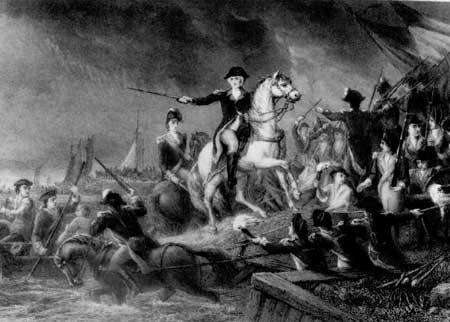
Defenders on Long Island fought desperately against all odds


The site of the Battle Pass is just north of the Prospect Park Zoo.


Battle Pass Marker


The Maryland Monument still stands at the south-central part of the park, nestled between Prospect Park Lake and Lookout Hill. The monument honors the brave fight by the First Maryland Continental Line, who courageously battled the British against all odds. I will save the story of the Maryland 400 for another post (actually, I have already posted about it).


The Maryland Monument


Site of the Dongan Oak - a huge tree felled to block the Flatbush Pass


There is a Quaker Cemetery near Lookout Hill that dates back to the 17th century. The Lefferts Homestead was located at Empire Boulevard and Flatbush Avenue. The original Dutch colonial farmhouse was accidentally burned by American defenders. The owner, Peter Lefferts, rebuilt the house during the latter part of the war using some of the original wood. In 1918, the family donated the residence to the city, and it was moved to Prospect Park from its original site at 563 Flatbush Avenue.


Restored Lefferts House


On a beautiful summer day, Prospect Park is filled with thousands of visitors walking, riding, visiting the zoo, or lounging by the lake. As Brooklyn experiences a kind of renaissance, the park and its lush greenery offer an ideal place to enjoy a touch of nature. But almost none of today's visitors know about the drama and tragedy that unfolded in the heart of their oasis.


Few visitors to Prospect Park today realize
they are on Hallowed Ground


Sunday, August 31, 2014

In the Navy!

 The Naval Advantage in 1776


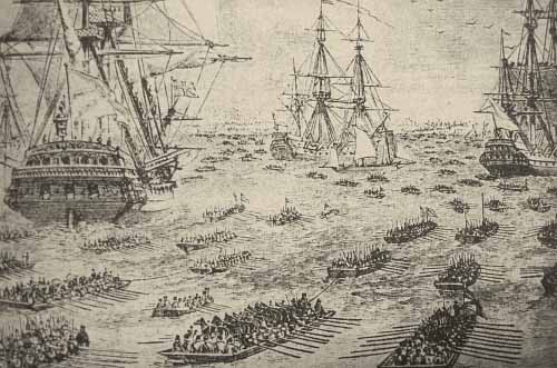
This past week marked the anniversary of the British landing on Long Island and the battle that shares its name. As most readers of this blog know, the invasion and the events that followed set the background for my novel, The Patriot Spy. I thought I’d use this blog to discuss the role of naval power in the campaign. The American Army under General George Washington essentially had no information about British plans after General William Howe withdrew his besieged forces from Boston. However, it wasn’t hard to see that the main British advantage in the war was the Royal Navy.

1776: British fleet at Staten Island 


Early Success, Defeat, and Triumphs


Destruction of the Spanish Armada


In some ways, the story of Britain is tied to its navy. During the time of the Yankee Doodle Spies, Britain had the greatest navy in the world and, more importantly, had over a century of knowledge and experience in using that advantage effectively. Many are familiar with the victories of the 16th-century English navy under Elizabeth I against the Spanish. However, during the 17th century, England and its navy went through a period of upheaval. 

The English Civil War, three wars with the Dutch (who had surpassed Spain as the world's leading mercantile and naval power), and the "Glorious Revolution" all affected the navy's development, both positively and negatively. During that period, the English and Scottish fleets merged but, on paper, remained separate. The Dutch Wars initially favored the Dutch, who achieved remarkable naval victories. 

Still, Britain gained the key Dutch colony of New Amsterdam (1664), and it learned how to develop its navy through the experience of defeat. By 1692, the British boasted the finest fleet in the world. The political alliance with the Dutch, which recognized their ruler William of Orange as William III of England, strengthened both navies. 

In a curious partnership, the Dutch fleet operated under British admirals in the subsequent wars with France and Spain that dominated the late 17th and most of the 18th century. The British were able to expand their global operations, and through a series of wars, they captured colonial possessions both large and small to support their naval and commercial needs.


Dutch burn the British fleet at Chatham


 Britannia rules the waves!


Royal Navy in Action


The Royal Navy of 1776 had a confidence rooted in achievement. Part of that success included what would later be called "combined arms" operations—using Royal Marines for small sea-land actions and collaborating with the Royal Army for major campaigns, mainly moving forces and guarding supply routes. This approach was developed during the Seven Years' War (French and Indian War) in North America. 

As the rebellion began, the Royal Navy became Britain's greatest advantage over the poorly connected coastal colonies, which were linked by a few poor roads. America depended on the sea, and controlling it was central to any plan to suppress the colonies. Trade could be blocked, starving the colonies that relied heavily on Britain for many finished goods. 

Ironically, this policy was among the grievances that sparked the rebellion. Britain's dominance at sea swayed some Loyalists' sympathies or at least their hostility toward the rebellion. To many, it seemed reckless to challenge the world’s strongest naval power—what was then the greatest global naval force ever. These concerns proved valid for most of the war. America had no real navy and was hurriedly building a small one, mostly to boost national pride rather than for strategic advantage. 

In reality, America’s naval strength came from privateers—many from merchant ships converted due to British control of the seas—another irony. Effective naval use allowed Howe to escape a tactical trap in Boston. It enabled him to execute a successful sea envelopment and move into New York Harbor, shifting the war’s focus and pace in Britain's favor.


Invasion, they're coming!


British landing at Gravesend on Long Island
(near the site of Brooklyn's Verazano Bridge)


The Royal Navy isolated New York from the sea and made its port useless. The port gave the city its strategic importance, as New York in the 18th century was not the largest city in America. The Royal Navy provided reconnaissance, naval gunfire, and transport for a series of landings at Staten Island, Gravesend, Kips Bay, and Westchester (Throgs Neck, Pelham, etc.). 

British naval movements confused the Americans and threatened nearby areas. General Howe had no plans to attack. More importantly, it limited General Washington's ability to move troops and forced him to defend a larger area than he could cover with his soldiers and guns. Surprise, maneuver, and firepower are key multipliers in any conflict, but they are even more effective when you also have overwhelming forces! 

As discussed in The Patriot Spy, only extremely unfavorable winds and tides kept the other Howe (Admiral Sir Richard, William's brother, and naval force commander) from surrounding Washington's forces on Long Island, who were tucked into a desperate defensive position on Brooklyn Heights. 

If conditions had been right, Howe's fleet could have bombarded Washington from behind and, combined with the army besieging Washington's front, forced surrender in the summer of 1776. Would losing George Washington and a large part of the Continental Army have ended the war then and there in Britain's favor? Well, that's the subject of another blog.


Saturday, July 13, 2013

How I Spent My Summer Vacation

New York - resort?


I took my annual summer resort vacation...in New York City! Now many folks wouldn't think of New York City as a resort and certainly not as a summer resort. But for most of its history, New York was precisely that - especially for the poor and middle class that make/made up so much of the city's populace. Why? Because they couldn't afford the time or the money to reach out to the numerous lakes in the mountains north of town or the expansive beaches of eastern Long Island. Nope, hundreds of thousands made do with the likes of the Bronx's Orchard Beach and City Island. The trolley and later the subway brought droves to Brooklyn's Coney Island, Manhattan Beach, Plum Beach, and Brighton Beach. Sheepshead Bay (it looks like a sheep's head from the air) offers deep-sea fishing at a reasonable price. And the prime resort area remains the Rockaways.  Queens's seven mile-plus stretch of sand from Far Rockaway to Rockaway Point with views of New Jersey's Atlantic Highlands provides some of the finest beaches on the east coast.


Some work - some play


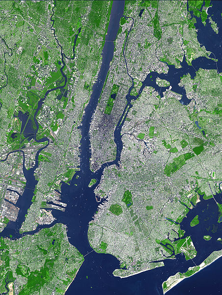
Although I was in Rockaway, this year my resort activity was somewhat curtailed.  I was under a deadline to get the edited manuscript of The Cavalier Spy reviewed and back to the publisher (done). So my summer fun in the sun was restricted to a one day visit to the beach. However, I took advantage of a special deal set up by NYC as a result of Hurricane Sandy.  Because of Sandy's impact on mass transit in the Rockaways, the city contracted a fast boat to go from Beach 108th Street and Jamaica Bay around the end of the Rockaways and up New York bay to lower  Manhattan. Readers of The Patriot Spy know Manhattan was called The Island of New York during the time of the American Revolution. The trip takes an average of 38 minutes each way for the round trip cost of $4! Like that, badabing, you are staring up at the lofty buildings of New York's financial district.  So what the heck does this have to do with the American Revolution? Well, the boat ride passed many of the critical points of the British invasion of New York back in the summer of 1776.


Sailing into the past


British cross the harbor towards Gravesend Bay


As the boat eased out of Jamaica Bay and turned into New York's impressive lower harbor, I could look to the southwest and see Sandy Hook, New Jersey. But back in 1776, the Sandy Hook included a sand bar that blocked the lower harbor, preventing large British warships from crossing over it except during extreme high tide. A few minutes later we were approaching the Verrazano Narrows. The British went through the narrows and landed an army of twenty-four thousand or so on Staten Island, then a Tory stronghold. After recovering for a few weeks they launched barges and longboats across the narrows and landed troops at Gravesend Bay. This was on my right (starboard side) just before I reached the narrows, not far from today's Fort Hamilton. The few American defenders there ran off at the sight of the British. We continued on another ten minutes with Bayonne on our port and Bay Ridge, then Red Hook, on our starboard. Near Red Hook is the Gowanus Canal: the remnant of the Gowanus Creek that played such a critical role in Washington's defenses on Long Island. The boat soon approached Governor's Island, where the Royal Governors resided during colonial times.  The last  Royal Governor of colonial New York, nasty William Tryon, evacuated a year earlier but returned in 1776 with the British armada.


The Sea Streak sails from the Rockaway peninsula on the lower right and up
the harbor to the lower extreme of Manhattan. Note the narrows and
 Governors Island. The Sandy Hook is just off the bottom of the photo,


The final heading


The Gloucester Regiment evacuates Washington's army from its defenses
near the Heights of Brooklyn
Passing the narrow channel between Governor's Island and Brooklyn, the boat entered the waters of the lower East River. To our starboard front lay Brooklyn Heights, just south of the famed Brooklyn Bridge. This was the location of Washington's headquarters during the battle for Long Island, and the point from which the Gloucester seamen evacuated the beleaguered army on a stormy night with the British front lines not more than a few hundred yards distant! The crossing from Brooklyn to New York was considerably wider than it is today, as the Manhattan's expansive use of landfill has narrowed the river by almost a quarter-mile.


The (old) City of New York


We arrived at lower New York, which during the time of the Yankee Doodle Spies extended not too far beyond today's Wall Street. We landed in the lower central portion of this image of early colonial New York. Note how the city abruptly ends at the Wall Street, it extended past Chambers Street by the mid-1700s.


Pearl Street was a contemporary thoroughfare about a half-mile north of where we landed. It probably looked little different from this image from the Dutch era, although the docks and buildings would be more extensive as the city had grown. I will do a future blog on some of the revolutionary war era sites that still remain in the city.  Of course, the march of history (not progress) has limited them to only a few.

Dutch-style buildings still dominated New York during the
time of the Yankee Doodle Spies


I

Friday, November 9, 2012

The Cortelyou House

The House

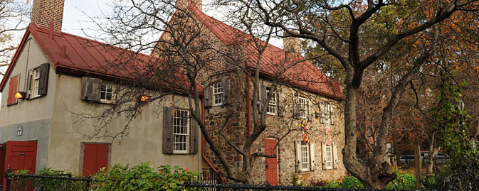
This edition of the Yankee Doodle Spies highlights the Vechte-Cortelyou House in Brooklyn, New York, the site of the high-water mark of the Battle of Long Island.

"Here on the 27th of August, 1776, Two hundred and fifty out of four hundred brave Maryland soldiers, under the command of Lord STIRLING, were killed in combat with British troops under CORNWALLIS."
...Inscription on a plaque commemorating the action near the Vechte-Cortelyou House, now called the Old Stone House.


Frontal View of the House today


The Vechte-Cortelyou House in Brooklyn, New York, was built in 1699 by a Dutch settler named Claes Arenston Vechte. Vechte and his family worked the land, farming the neat fields and grazing animals in the verdant pastures of this rich farmland.  They also gathered oysters and other bounty from the nearby Gowanus Creek, which they used to ship their produce to Manhattan.  Around the time of the revolution the land was leased to the Cortelyou family, and one of them later purchased the property.  The simple architecture is classic Dutch colonial with a mixture of stone and mortar, steep tiled roof and a wood shingled appendage (what we might today call a "bump-out") that appears to function as the kitchen.

Major General Cornwallis

The house was situated near the intersection of today's 3rd Avenue and 5th Street in Park Slope. During the events leading up to the cataclysmic fight that took place there, the house served as the headquarters of William Alexander, who called himself "Lord Stirling," because of a claim to that Scottish peerage.While holding the passes south of the house, Lord Stirling found his army surrounded when Major General (himself a Lord) Cornwallis' force of several thousand seized the area around the house after a night march down the Jamaica Road into the unguarded east flank of the American Army. 


Lord Stirling


While he ordered most of his forces to attempt escape across the Gowanus Creek, Lord Stirling led some 400 hundred Continental Line from Maryland and Delaware against the British defending near the Old Stone House, which they had turned into a strong defensive position. Stirling led six assaults against the British at that location and around 250 Americans were killed there and are buried nearby (see my earlier blog on trying to find them entitled "On Hallowed Ground").  The importance of this battle is fully described in The Patriot Spy, and the fictional events that I added form the genesis of the Yankee Doodle Spies.
Thumbnail for version as of 09:46, 25 August 2011

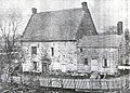
The Original House


Interestingly, in the 19th century the original house once served as the headquarters of the Brooklyn baseball club that later became the famed Brooklyn Dodgers. You can see from this photograph the once prosperous farmstead had by the latter 19th century fallen into disrepair. 

Back View of The Old Stone House Today


The original Cortelyou House was later torn down but a reconstruction was built from dug up debris and replica materials and can be found in J.J. Byrne Park in the Park Slope section of Brooklyn. It serves as a museum that celebrates the events of August 1776 that took place on the hallowed ground around it. 
Sadly, little of the feel or look of the times can be found there.  However, nearby Prospect Park and Greenwood Cemetery do present views that might have been "enjoyed" by Lords Stirling and Cornwallis back in August of 1776.
As you can see, the reconstructed house is smack in the heart of a major urban area.  Note the Gowanus Canal, the remains of the Gowanus Creek, not too far distant. 

Where in the world is the Cortelyou House?

Saturday, September 29, 2012

The First Patriot Spy?

Nathan Hale


Earlier this week marked the 236th anniversary of Nathan Hale's death. Hale is a minor yet significant figure in the first two books of the Yankee Doodle Spies Series.

On September 22, 1776, Nathan Hale, the first American (not rebel) spy, was hanged by the British. Born in 1755 on a farm near Coventry, Connecticut, Hale attended Yale and, after graduating in 1773, became a schoolteacher. Caught up in the patriotism sweeping the colonies after the battles of Lexington and Concord, he joined the Continental Army forming around Boston in 1775. Initially ambivalent, Hale decided to join the Cause after receiving a letter from his close friend, Benjamin Tallmadge, urging him to serve. Ironically, or perhaps causally, Tallmadge later became the head of Washington's intelligence unit (and a recurring character in Yankee Doodle Spies).

Hale rose to the rank of Captain in a Connecticut Regiment but later joined Lieutenant Colonel Thomas Knowlton's (also a peripheral figure in the series) elite Ranger battalion. Hale was, by all accounts, an extremely handsome man—tall for his era—and very well-spoken. Liked by everyone, his commander, Knowlton, held him in special regard. After the Continental Army retreated from its disastrous defense of Long Island, Lieutenant General George Washington needed to assess the strength, activities, and morale of the British occupiers. Washington was especially concerned about the timing and location of the inevitable British assault on the Island of New York (now called Manhattan). He asked Knowlton to provide an agent for this very high-risk mission. In a society obsessed with "honor," espionage was considered even dirtier than it is today. Because of that, none of the officers in Knowlton's unit volunteered. But Hale, who had yet to see combat and was bored with the administrative duties he had so far, offered his services.
Spying under spurious cover?

In a mission both daring and futile, he was clandestinely transported onto Long Island from Connecticut by longboat, disguised as an itinerant schoolmaster. In a lesson in tradecraft, the idea of a young schoolmaster traveling through a war zone seems desperate, if not downright absurd. However, Hale was indeed a schoolmaster, and it’s always easier to depict something similar to your own experience or background. The exact details of his capture are a matter of much debate. In his book, *Washington's Spies*, author Alexander Rose states that the renowned Loyalist Ranger Robert Roberts captured him. Roberts was a hero during the French and Indian War but switched allegiances and sold his services to the British during the American Revolution. According to Rose, Roberts and his men identified Hale on Long Island and lured him into a trap. Other accounts tell a different story. Regardless, the cover was blown.

A Spy Uncovered


What we do know for sure is that Hale was captured on September 21 and immediately brought in for questioning by the British commander, General William Howe. By then, the British Army had already invaded New York. Howe had just moved into the Beekman Mansion, near the current corner of 51st Street and 1st Avenue in Manhattan. Intelligence found on Hale, which was not in code or invisible ink, meant he was completely compromised.

The next morning, a Sunday, the former spy was marched north about a mile along the post road to the Park of Artillery, located next to a pub called the Dove Tavern, roughly 5 1/2 miles from the city limits. There, he was hanged. Hale's supposed quote before execution is somewhat debated, and several different accounts exist from various sources, all of which seem plausible. Traditionally, hanging was reserved for thieves and murderers, not soldiers, especially not officers. It’s likely Hale intended his last words to both dispel the dishonor of being labeled a spy and to serve as a model of patriotic sacrifice.

I have but one duty...

To me, the most credible statement reportedly made by Nathan Hale before his execution comes from the diary of a British officer named Lt. Robert MacKensie, who was serving in New York at the time. The entry is especially believable because it was written on the very day of Hale's execution.

"...He behaved with great composure and resolution, saying he thought it the duty of every good Officer, to obey any orders given him by his Commander-in-Chief; and desired the Spectators to be at all times prepared to meet death in whatever shape it might appear."

Saturday, September 1, 2012

On Hallowed Ground


In an earlier post, I talked about the origins of setting The Patriot Spy during the Battle of Long Island. Several times while writing the book, I revisited the neighborhoods involved in the battle. Some of these were neighborhoods I had lived in long ago, like Park Slope and Flatbush - both in the heart of Brooklyn.

On one of my return trips, I went to the place I believed was the site of the pivotal point of the battle – the forlorn hope attack by the brave Marylanders and their brothers in arms from Delaware (who are actually depicted on the cover of The Patriot Spy). It was a gray autumn day. We drove to the intersection of 3rd Avenue and 8th Street in Park Slope – the spot where I thought the fallen 300 from the engagement had been laid to rest.  


There, in front of an auto repair shop, I stood looking at an old building across the street. Surrounded by scaffolding, it was clearly in the process of being demolished. A large, burly guy with a thick gold necklace saw me standing there and came out of the repair shop.

“Can I help you?” He asked, more as a challenge than a question, with a thick Brooklyn accent.
“I’m looking for a marker,” I replied.  One of the sourcebooks I used indicated the existence of a small marker on the side of a building.
“A marker?  Marker for whad?”  He asked with a really puzzled look.
“Almost three hundred  Americans died here and are buried in a mass grave,” I answered.
“Died? When?  How? Who done it?” He looked stunned and puzzled, and this being Brooklyn, likely thought this had something to do with the mob. 
“There was a great battle here in 1776.  Almost three hundred patriots were killed fighting the British and are supposed to be buried near here.”
He nodded his head knowingly. “Oh yeah, well, I ain’t never seen no marker, but it wuz probably on dat building.”

I looked across the street at the building, now wrapped in scaffolding and plywood, surrounded by a chain-link fence. I decided my search was over.  

I share this story to draw readers' attention to a recent article in the New York Times about a Brooklyn historian named Bob Furman. Furman is working to identify, preserve, and properly commemorate important sites on the battlefield. The article is worth reading because it highlights the difficulties of maintaining a sense of history amid urban growth.

Gowanus Canal


More than a hundred years ago, a growing city’s demand for residential and industrial land overwhelmed the area. It’s hard to believe that this densely developed part of New York was once filled with beautiful farms, fields, orchards, and woods. It’s also hard to believe that brave and gallant men once fought desperately for their lives and their new nation on these busy streets. Let's hope Furman and his team at the Brooklyn Preservation Council succeed in reclaiming some of this sacred ground. Sadly, most remnants of the Revolutionary War battle and the terrain where it was fought are now gone.